CANADA HISTORY
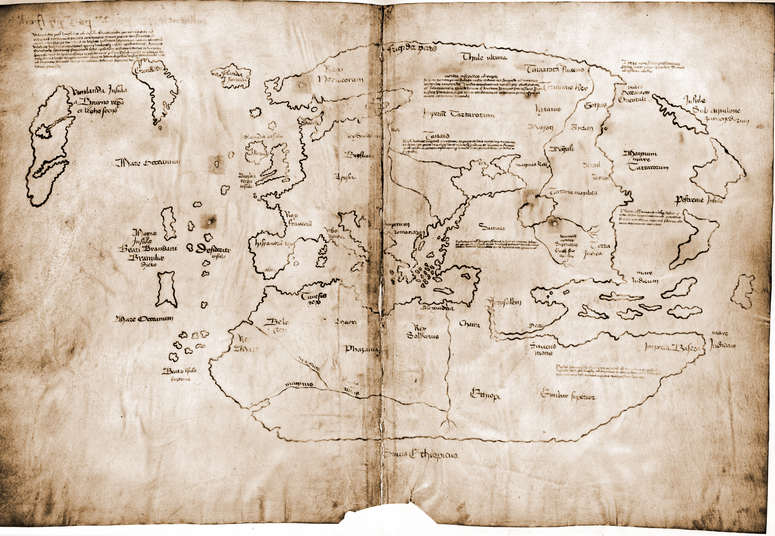
The Vinland Map, an artifact that claims to predate Christopher Columbus's voyage to the Americas by some 80 years, is one of the most controversial and debated historical documents in the field of exploration history. If authentic, the map would represent groundbreaking evidence of Viking exploration in the North Atlantic and offer tangible proof that Europeans were aware of the existence of North America long before Columbus set sail in 1492. The ongoing debate surrounding the authenticity of the map, its implications, and the rigorous scientific testing to either confirm or refute its validity have significant importance for Canadian history, as it pertains to the earliest European contact with the continent.
First published in 1965 by R. A. Skelton, Thomas Marston, and George Painter in their book The Vinland Map and Tartar Relation, the Vinland Map purportedly outlines Viking explorations and discoveries in the North Atlantic. It shows a depiction of a landmass labeled "Vinland" to the west of Greenland, corresponding with the descriptions found in the Vinland sagas of the 11th-century Norse exploration of North America. According to the map’s proponents, this would indicate that Europeans not only explored but documented the existence of Vinland—likely part of modern-day Newfoundland—decades before Columbus’s famed transatlantic voyage.
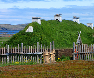
The discovery of this map was heralded as a monumental find, offering potential proof that Europeans had mapped North America in the 15th century, long before it became widely known. The map, if genuine, would validate the saga accounts of Leif Erikson’s journey to Vinland and provide critical evidence to support claims of early Viking settlement in Canada. Given the significant archaeological evidence unearthed at L'Anse aux Meadows in Newfoundland in the 1960s, which confirmed Norse settlement in North America, the timing of the Vinland Map’s discovery seemed to corroborate historical accounts of Viking exploration.
However, skepticism about the map’s authenticity arose almost immediately, spurring a series of scientific tests and scholarly debates that have lasted for decades. One of the earliest challenges came in 1972 when a team of scientists, led by Dr. Walter McCrone, analyzed the ink used on the map. McCrone's findings revealed that the ink contained anatase, a form of titanium dioxide, which had not been used in inks until the 20th century. The presence of anatase seemed to suggest that the map was a modern forgery, created sometime after the 1920s, rather than a medieval document from the 1400s.
This revelation sparked widespread criticism and led many scholars to denounce the Vinland Map as a hoax. The presence of modern ink on what was claimed to be a 15th-century document called the entire narrative into question. If the map were proven to be a forgery, it would cast doubt on the integrity of the document, undermining its significance as a historical artifact. Furthermore, it would shift the narrative of early European knowledge of North America back to the time of Columbus, rather than the Viking era.
However, in 1992, a new development reopened the debate when Dr. Thomas Cahill of the University of California, Davis, conducted additional tests and found anatase in several genuine medieval manuscripts. Cahill’s findings suggested that the presence of anatase in the ink might not be definitive proof of forgery after all. This discovery reignited the controversy and led to further studies, as the possibility that the map might indeed be authentic once again came into consideration.
The conflicting results of scientific testing have left the academic community divided. In 1995, Yale University, which had initially unveiled the map, published a second edition of The Vinland Map and Tartar Relation that included additional articles supporting the map’s authenticity. Despite these efforts, skepticism persisted among many scholars, and the map’s legitimacy remained a subject of intense debate.
In recent years, two new studies have further complicated the question. One study examined the parchment on which the map was drawn, confirming that it dates back to the 15th century. This finding would seemingly support the map’s authenticity, as it suggests that the parchment itself is genuinely from the medieval period. However, another study focused on the ink used in the map, and once again raised concerns about the presence of modern materials. These conflicting results have left the historical and scientific communities with no definitive conclusion regarding the map’s authenticity.
The importance of the Vinland Map lies not only in the potential it holds as a historical document but also in the broader implications for Canadian history. If authentic, the map would represent one of the earliest European records of North America, predating Columbus’s voyages and confirming Viking exploration and settlement in what is now Canada. The map would offer concrete evidence that Vinland, as described in the Norse sagas, was known to European cartographers and was significant enough to be included in a map before the so-called Age of Discovery.
For Canadian history, the Vinland Map is a testament to the early presence of Europeans in North America and further emphasizes the importance of Viking exploration to the history of the continent. The map would add to the narrative of L'Anse aux Meadows, the archaeological site in Newfoundland where Norse explorers established a settlement around the year 1000 AD. It would also highlight the significance of Viking maritime prowess and the wide-reaching influence of their explorations, which extended far beyond the borders of Europe.
Furthermore, the map serves as a reminder of the complexities and uncertainties inherent in historical research. The debate over the Vinland Map illustrates the challenges historians and archaeologists face when attempting to piece together the past from fragmentary evidence. The ongoing debate also reflects how new scientific techniques can challenge long-held assumptions, offering new insights but also raising new questions.
In conclusion, the Vinland Map remains one of the most debated and enigmatic artifacts in the study of early exploration. Whether genuine or forged, it has captured the imagination of historians and the public alike, symbolizing the enduring mystery of Viking exploration in North America. Its significance for Canadian history cannot be overstated, as it speaks to the earliest European attempts to map and understand the lands that would one day become part of Canada. Whether or not the map is proven to be authentic, it continues to fuel important conversations about early European contact with North America and the ways in which history is constructed and understood.
Cite Article : www.canadahistory.com/sections/documents